
Alton 4 Stars Hotels
 Change your mindBook hotels with free cancellation
 Be pickySearch almost a million properties worldwide
Check availability on Alton 4 Star Hotels
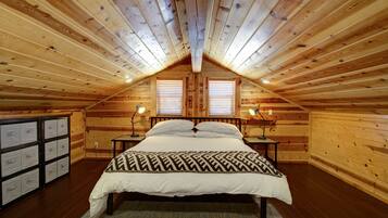
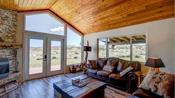
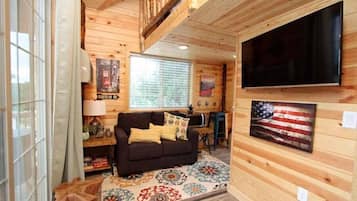
Our top choices for Alton 4-star hotels

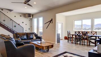

10.0 out of 10, Exceptional, (12 reviews)
"Peaceful and beautiful retreat with everything needed for base camp while hiking at Bryce. "

Anonymous traveller


9.8 out of 10, Exceptional, (10 reviews)
"We found this trough Amex Expedia offers and it was more than expected. The house was clean well kept with beautifully curated interior. The view of the mountains the river that runs through the property was dreamy. We couldn’t make it the first night due to snow storm and the manager was so thoughtful and helpful assisting us and making sure we enjoyed our stay. The property is well maintained and they pay close attention to detail including list of to do and to visit while you stay in the are...
Hosana


9.4 out of 10, Exceptional, (16 reviews)
"Clean, cozy and beds were amazing, slept like a dream."
Anonymous traveller

Save an average of 15% on thousands of hotels when you're signed in
Learn more about Alton
Nestled near the stunning Dixie National Forest, this tiny town offers hikers access to Red Hollow Canyon Trailhead and Mammoth Cave. Explore the natural wonders of Bryce Natural Bridge and Fairview Point, where southern Utah's remarkable landscapes unfold in every direction.

Photo by Eric & Kristy's Adventures
Open Photo by Eric & Kristy's Adventures
Top Alton Hotel Reviews
Frequently asked questions
Explore a world of travel with Expedia
- Holiday Parks in Southwestern Utah - Bryce Canyon
- Spa Hotel Hotels in Kanab
- La Quinta Inn & Suites Hotels in Mount Carmel
- Hotel with Pool Hotels in Kanab
- 3 Star Hotels in Hatch
- Hotels near Thunder Mountain Motorsports
- Cabin Rentals in Cedar City
- Cottages in Kanab
- Motels in Cedar City
- Hotels near Zion Canyon Visitor Center
- Motels in Kanab
- Resorts in Southwestern Utah - Bryce Canyon
- Cabin Rentals in Mount Carmel
- Apartments in Hatch
- Historic Hotel Hotels in Glendale
- Hotels near Bryce Natural Bridge
- Bar Hotel Hotels in Kanab
- Hotels near Ebenezer's Barn and Grill
- Villas in Glendale
- Hatch Hotels
- Cheap Hotels in Cannonville
- Kanab Hotels
- Casino Hotel Hotels in Southwestern Utah - Bryce Canyon
- Condo Rentals in Cedar City
- Springdale Hotels
- 4 Star Hotels in Hurricane
- Cabin Rentals in Glendale
- Panguitch Hotels
- Hotels near Hop Valley Trail
- Luxury Hotel Hotels in Bryce Canyon
- Waterpark Hotels in Cedar City
- Hotels near Emerald Pools
- B&B in Southwestern Utah - Bryce Canyon
- Cheap Hotels in Cedar City
- Brian Head Hotels
- Hotels near Zion National Park South Entrance
- Cabin Rentals in Duck Creek Village
- 5 Star Hotels in Southwestern Utah - Bryce Canyon
- Rv Parks in Southwestern Utah - Bryce Canyon
- Hotels near Bryce Canyon National Park Visitor Center
- Cheap Hotels in Bryce Canyon
- Hotels near Brian Head Ski Resort
- Cabin Rentals in Alton
- Hotels near Pine Creek Canyon Trailhead
- Hotels near Zion National Park
- Tropic Hotels
- B&B in Kanab
- Resorts in Parowan
- B&B in Parowan
- Hotels near Temple of Sinawava Trail
- Cabin Rentals in Panguitch
- 3 Star Hotels in Parowan
- Villas in Springdale
- B&B in Hatch
- Hotels near Sunrise Point
- Family Hotel Hotels in Bryce Canyon
- Hotels near Navajo Lake
- Hotel with Pool Hotels in Duck Creek Village
- Rv Parks in Panguitch
- Luxury Hotel Hotels in Glendale
- Cannonville Hotels
- Motels in Springdale
- Bryce Canyon Hotels
- 3 Star Hotels in Long Valley Junction
- Vacation Homes in Cedar City
- Apartments in Mount Carmel
- Lodges in Bryce Canyon
- Alton Hotels
- Cabin Rentals in Brian Head
- Hotels near Sunset Point
- Hotels near Bryce Canyon National Park
- Cedar City Hotels
- Bar Hotel Hotels in Panguitch
- Hotels near Coral Pink Sand Dunes State Park
- Cabin Rentals in Tropic
- Flights from Bryce Canyon
- Flights from Las Vegas (LAS) to Bryce Canyon (BCE)
- Flights from Chicago (ORD) to Bryce Canyon (BCE)
- Flights from Salt Lake City (SLC) to Bryce Canyon (BCE)
- Flights to Rockville
- Flights from Orlando (MCO) to Bryce Canyon (BCE)
- Flights from Hatch
- Flights from Alton
- Flights to Parowan